
DJI Matrice 4 Series
Enterprise Drones
The Age Of Intelligent Flight
The DJI Matrice 4 Series is a compact enterprise drone platform built for professional inspection, public safety, emergency response, surveying, mapping, construction, mining, and other data-driven operations.
The series includes two models. The DJI Matrice 4T is designed for inspection, thermal imaging, public safety, emergency response, utilities, and forestry applications. The DJI Matrice 4E is built for surveying, mapping, construction, mining, and other geospatial workflows.
Both models combine multiple cameras, laser range finding, intelligent flight features, and advanced sensing in a portable enterprise platform.
Terra Excel Drones supplies DJI Matrice 4 Series enterprise drones in Canada and can help you compare the Matrice 4T and Matrice 4E based on your operation and data requirements.
48 MP tele camera1,800 m laser range finder25 km O4 Enterprise640 × 512 thermal (4T)20 MP 4/3 mechanical shutter (4E)
DJI Matrice 4T vs. Matrice 4E: What’s the Difference?
Both models include telephoto cameras and a laser range finder. The Matrice 4T adds thermal imaging and NIR illumination, while the Matrice 4E uses a 20 MP 4/3 CMOS wide-angle camera with a mechanical shutter for mapping and survey work.
DJI Matrice 4T
The DJI Matrice 4T is designed primarily for inspection, thermal imaging, public safety, emergency response, utilities, and forestry. The DJI Matrice 4E is designed for surveying, mapping, construction, mining, and geospatial data collection.
- Wide-Angle · 1/1.3″ CMOS · 48 MP · f/1.7 · 24 mm
- Medium Tele · 1/1.3″ CMOS · 48 MP · f/2.8 · 70 mm
- Tele · 1/1.5″ CMOS · 48 MP · f/2.8 · 168 mm
- Laser Range Finder · 1,800 m · 600 m oblique · ± (0.2 + 0.0015 × D)
- Thermal · 640 × 512 · f/1.0 · 53 mm · uncooled VOx · High-Res Mode
- NIR Auxiliary Light · 6° FOV · up to 100 m
DJI Matrice 4E
The DJI Matrice 4E is built for surveying, mapping, construction, mining, and other geospatial work. Its camera system combines a 20 MP wide-angle camera with a mechanical shutter, two telephoto cameras, and a laser range finder to support detailed aerial data capture and site documentation.
- Wide-Angle · 4/3 CMOS · 20 MP · f/2.8–f/11 · 24 mm · mechanical shutter
- Medium Tele · 1/1.3″ CMOS · 48 MP · f/2.8 · 70 mm
- Tele · 1/1.5″ CMOS · 48 MP · f/2.8 · 168 mm
- Laser Range Finder · 1,800 m · 600 m oblique · ± (0.2 + 0.0015 × D)
DJI Matrice 4 Series AI and Intelligent Flight Features
The Matrice 4 Series combines onboard AI, laser measurement, tracking, and flight-recording tools to help enterprise operators collect information and respond more efficiently during inspections, public safety work, search and rescue, and routine field operations.
AI Detection and Tracking for Enterprise Operations
Onboard AI adds automatic recognition for vehicles, vessels, and other subjects, giving operators another tool for routine missions and search-and-rescue work. Additional AI models can also be used to expand the system for different applications.
Integrated Laser Range Finder and Measurement Tools
The integrated laser range finder allows operators to measure distance, mark locations, draw lines, and calculate areas directly during flight. That information can support inspection work, emergency response, wildfire assessment, and other operations where accurate location data matters.
Measurements and location information can also be shared through the DJI Pilot QR code or FlightHub 2 to support communication between field teams.
Mapped Observation Coverage in DJI Pilot 2
DJI Pilot 2 can record the centre of the camera view and the ground area being observed, then display that coverage on the map. This gives operators a clearer record of where they have already looked, which can be especially useful during patrols and search operations in areas without obvious landmarks.
DJI Matrice 4 Series Intelligent Flight Modes
The Matrice 4 Series includes automated flight tools that reduce repetitive control inputs and help operators manage inspections, emergency response, observation, and modelling work more efficiently.
Smart Track
Smart Track helps operators follow a selected subject while automatically adjusting zoom and positioning. If the subject is temporarily obscured, the system can reacquire it once it becomes visible again.
Cruise
Cruise mode keeps the aircraft travelling in a selected direction without requiring continuous stick input, making longer inspection, patrol, and observation flights easier to manage.
FlyTo
FlyTo allows the aircraft to calculate its route and adjust flight speed based on the surrounding environment as it travels toward a selected location. This can be particularly useful when teams need to reach an area quickly during emergency response or disaster operations.
POI
Point of Interest mode allows the aircraft to circle a selected location while maintaining observation of the subject. It can also support 3D modelling of structures during fixed-point inspection and documentation work.
DJI Matrice 4 Series Low-Light and Thermal Imaging
The Matrice 4T includes NIR illumination to help operators maintain visibility when available light is limited, supporting nighttime inspection, monitoring, and wildlife applications.
Night Scene Mode for Low-Light Operations
Full-Colour night vision offers three operating modes and two levels of noise reduction to improve visibility after dark. The system also uses an IR Cut Filter and NIR auxiliary lighting to help operators identify subjects and surrounding details in low-light environments.
DJI Matrice 4T Thermal Imaging
High-Res infrared imaging on the Matrice 4T can produce thermal images up to 1280 × 1024. Ultra-High Resolution mode provides additional temperature detail for inspection and monitoring work. Each unit is calibrated for temperature accuracy, while the onboard temperature sensor supports real-time temperature measurement.
NIR Auxiliary Light
The Matrice 4T includes NIR illumination with a range of up to 100 metres, helping operators observe objects and subjects where available light is limited.
Low-Light Fisheye Omnidirectional Sensing
Six high-definition fisheye vision sensors support aircraft positioning and obstacle awareness in low-light environments. These sensors also contribute to automatic obstacle avoidance, rerouting, and return-to-home functions when operating around buildings or other complex surroundings.
Low-Light Photography for Dusk and Night Operations
Larger camera apertures and intelligent low-light processing help the Matrice 4 Series capture clearer imagery during dusk, nighttime, and other low-light conditions.
DJI Matrice 4 Series Telephoto Imaging
Crystal Clear Vision. Unveil the Details. Capture Every Detail at A Distance.
48 MP Telephoto Imaging
The Matrice 4 Series uses a 48 MP tele camera to capture fine detail from farther away, including information on signs at distances up to 250 metres. On the Matrice 4T, an IR-Cut Filter also supports imaging across changing daytime and nighttime conditions.
Telephoto Stabilization at 10× Zoom and Above
Telephoto stabilization helps keep foreground subjects steady when working at 10× zoom or greater. This gives operators a clearer view of the details they are monitoring during inspections, public safety operations, and other observation work.
Electronic Dehazing for Haze and Humidity
Electronic Dehazing gives operators three adjustment levels, Low, Medium, and High, to improve image visibility when atmospheric conditions such as haze or humidity make distant subjects harder to see.
Medium-Range Inspection Imaging. The medium tele camera gives inspection teams another option between wide-angle and long-range telephoto views. For infrastructure work, it can capture details such as screws and surface cracks from approximately 10 metres away and help operators read instrument information at substations without moving the aircraft unnecessarily close.
DJI Matrice 4E Surveying and Mapping
0.5-Second Interval Shooting for Aerial Mapping
The Matrice 4E is designed for high-speed aerial mapping with image capture intervals as short as 0.5 seconds in orthophoto and oblique photography modes.
With mapping flight speeds up to 21 m/s, survey and mapping teams can collect imagery across larger areas while maintaining the capture frequency needed for detailed reconstruction.
Smart 3D Capture for Detailed Structure Mapping
Smart 3D Capture lets operators create an initial model directly on the remote controller before generating a more detailed flight route around the structure.
The aircraft can then plan closer mapping paths around irregular buildings and other complex surfaces for detailed measurement and modelling. Virtual flight routes and waypoint images also give operators a way to review planned coverage and route conditions before collection begins.
5-Directional Oblique Capture
For oblique mapping, the Matrice 4 Series can automatically position the gimbal to collect imagery from five different directions across the survey area. Capturing multiple perspectives during the same flight gives mapping teams the imagery needed for detailed 3D reconstruction without relying on separate passes for every viewing angle.
3-Directional Ortho Capture
Three-directional ortho capture adds lateral imagery to standard orthophoto collection while reducing the amount of side overlap required between flight lines. A single Matrice 4E flight can map up to 2.8 square kilometres, while the workflow removes the need for a separate elevation-optimization route. When paired with DJI Terra, the captured imagery can move directly into the reconstruction process.
In-Camera Distortion Correction for Mapping Accuracy
Distortion Correction 2.0 applies correction within the camera and keeps residual distortion below two pixels. Each Matrice 4E wide-angle camera is calibrated at the factory, providing a stronger foundation for accurate reconstruction when imagery is processed through DJI Terra.
DJI Pilot 2 Survey Quality Reports
After a survey flight, DJI Pilot 2 can generate a quality report showing information such as image capture points, RTK status, and camera parameters. Having that information available before leaving the site gives survey teams a chance to identify missing or questionable data and collect additional imagery while they are still in the field.
DJI Matrice 4 Series Positioning and Return-to-Home
RTK, GNSS and Vision Positioning
An integrated DJI RTK module combines GNSS positioning with visual navigation and supports the extended L5 frequency band.
Visual positioning can update the return-to-home point and allows the Matrice 4 Series to prepare for takeoff in as little as 15 seconds. If GNSS becomes unavailable, the vision-based positioning system can continue supporting the return-to-home process, giving operators another layer of navigation support around buildings and other environments where satellite signals may be obstructed.
Terrain-Aware Route Planning and Vision Assist
When the DJI RC Plus 2 Enterprise is online, operators can access terrain elevation data and preload detailed maps before flight. The Matrice 4 Series can use that information when planning routes around obstacles, adding useful support for operations in mountainous terrain, low-light conditions, and other complex environments.
Five directional vision-assist views, together with downward vision, give pilots additional visibility around the aircraft while planning and completing a flight.
DJI Matrice 4 Series O4 Enterprise Video Transmission
DJI’s O4 Enterprise transmission system combines eight antennas on the Matrice 4 Series with a high-gain antenna on the controller and supports transmission distances up to 25 km under specified FCC test conditions. Actual transmission range varies with the operating environment, interference, regional regulations, and other flight conditions.
A download bandwidth of up to 20 MB/s supports faster movement of imagery, flight routes, and other operational data between the aircraft and controller.
For operations where additional connectivity is required, the Matrice 4 Series also supports the optional DJI Cellular Dongle 2. This adds 4G transmission alongside the aircraft’s existing communication system to provide another connection option in challenging environments.
DJI Matrice 4 Series Accessories
The Matrice 4 Series can be configured with DJI Enterprise accessories for lighting, communication, positioning, and field operations, allowing teams to build the aircraft around the work they need to complete.
DJI AL1 Spotlight
The DJI AL1 Spotlight provides illumination up to 100 metres away and includes Always-On and Strobe modes. When linked with the gimbal, the spotlight follows the camera’s movement so the illuminated area stays aligned with what the operator is viewing. Operators can concentrate the light on a specific subject or use a wider field of view when a larger area needs to be illuminated.
DJI AS1 Speaker for Live and Recorded Broadcasts
The DJI AS1 Speaker supports broadcasts at distances up to 300 metres and can reach up to 114 dB when measured at one metre. Operators can use recorded messages, imported audio, text-to-speech, or live broadcasting. Echo suppression helps improve clarity during real-time communication, including emergency response and search-and-rescue operations.
High-Precision D-RTK 3 Multifunctional Station
The D-RTK 3 Multifunctional Station adds centimetre-level positioning support for precision surveying and mapping workflows. It can operate as a base station for multiple aircraft or as a relay station when teams need additional operational range. Rover Station Mode works with the DJI Enterprise app and DJI Terra to support high-precision aerial survey workflows.
DJI RC Plus 2 Enterprise
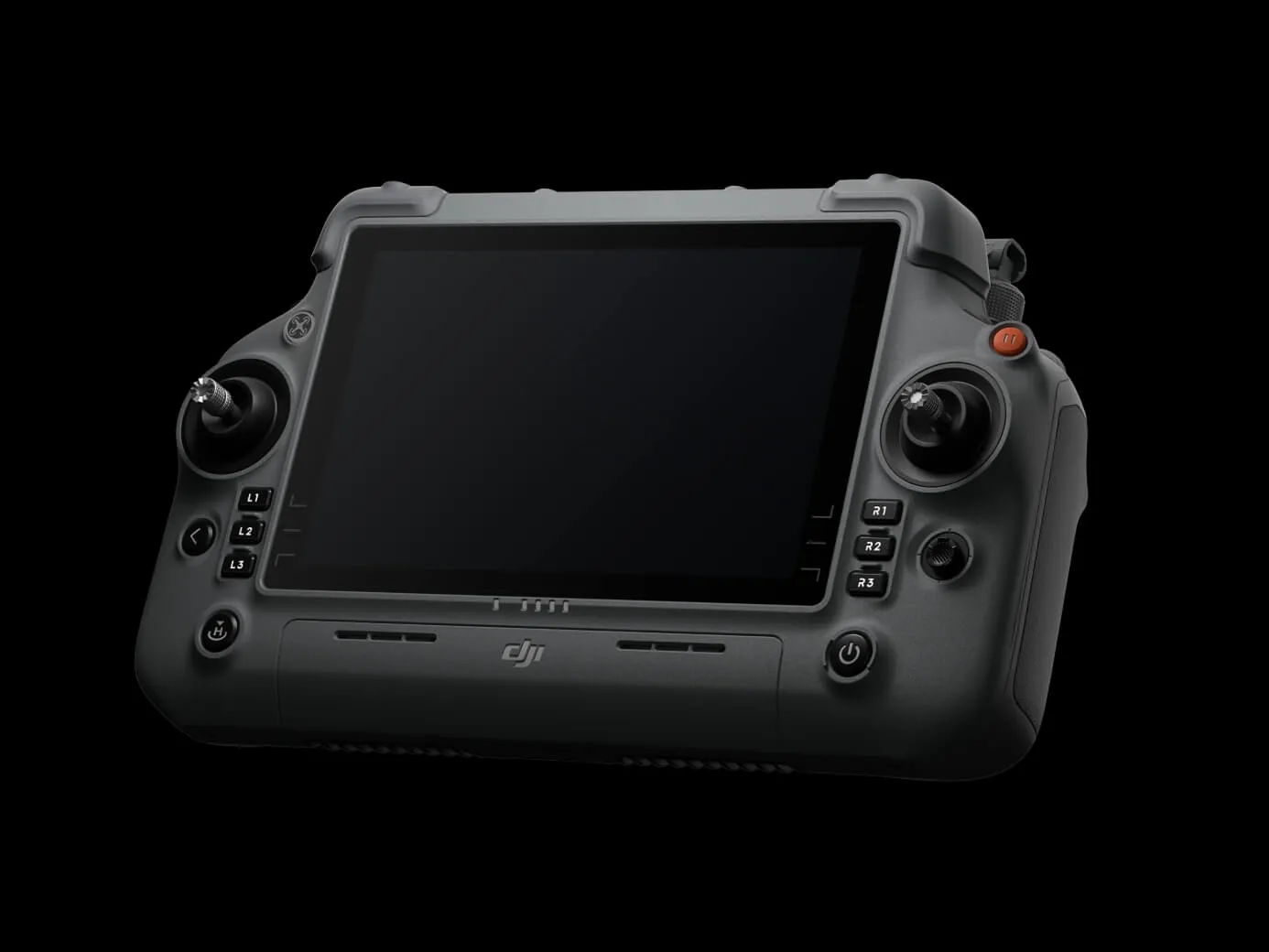
The DJI RC Plus 2 Enterprise is built for field operations with a high-brightness display that remains visible in direct sunlight, an IP54 protection rating, and an operating temperature range of -20°C to 50°C. Its built-in high-gain antenna array supports the O4 Enterprise transmission system, while optional 4G hybrid transmission provides another connectivity option for operations around high-rise buildings, mountainous terrain, and other environments where maintaining a stable connection can be more challenging.
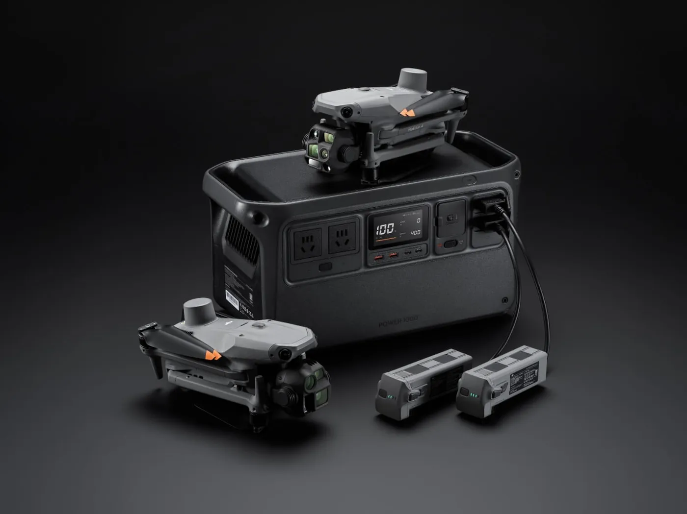
DJI Power 1000 for Matrice 4 Series Charging
The DJI Power 1000 gives Matrice 4 Series operators a portable charging option for longer days in the field. It supports up to 200 W fast charging for Matrice 4 Series Intelligent Flight Batteries, with a full battery charge taking approximately 48 minutes. With up to 2,200 W of AC output, the Power 1000 can also support other equipment used on site. Pairing it with the DJI Power 1kW Car Charger adds up to 1 kW charging from a vehicle, giving field teams another way to keep batteries and equipment powered between operations.
DJI Matrice 4 Series FAQ
Common questions about the DJI Matrice 4T and Matrice 4E, answered by Terra Excel Drones.
What is the difference between the DJI Matrice 4T and Matrice 4E?
The DJI Matrice 4T is designed for inspection, thermal imaging, public safety, emergency response, utilities, and forestry. The Matrice 4E is designed for surveying, mapping, construction, mining, and other geospatial applications. Both include telephoto cameras and a laser range finder, while the 4T adds thermal and NIR imaging and the 4E adds a 4/3 CMOS wide-angle camera with a mechanical shutter.
Does the DJI Matrice 4T have a thermal camera?
Yes. The Matrice 4T includes an infrared thermal camera and supports High-Res Mode with thermal images up to 1280 × 1024. It also includes onboard temperature sensing for real-time temperature measurement.
Is the DJI Matrice 4E designed for surveying and mapping?
Yes. The Matrice 4E is built for surveying, aerial mapping, construction, mining, and geospatial data collection. It supports 0.5-second interval shooting, oblique and orthophoto capture, Smart 3D Capture, and integration with DJI Terra.
Does the DJI Matrice 4 Series support RTK?
Yes. The Matrice 4 Series includes an integrated DJI RTK module with support for the extended L5 frequency band. It combines GNSS and visual positioning to support accurate navigation and return-to-home functions.
Can the DJI Matrice 4E create 3D models?
Yes. Smart 3D Capture allows operators to create an initial model using the remote controller and then generate detailed flight routes around buildings and other structures for measurement and 3D modelling.
Can the DJI Matrice 4 Series operate in low-light conditions?
The Matrice 4 Series includes low-light cameras and six low-light fisheye vision sensors to support positioning and obstacle awareness after dark. The Matrice 4T also adds NIR illumination and thermal imaging for operations where visible light is limited.
What accessories are available for the DJI Matrice 4 Series?
Available DJI Enterprise accessories include the DJI AL1 Spotlight, DJI AS1 Speaker, D-RTK 3 Multifunctional Station, DJI RC Plus 2 Enterprise, DJI Cellular Dongle 2, and DJI Power 1000 charging solutions.
Where can I buy the DJI Matrice 4T or Matrice 4E in Canada?
Terra Excel Drones supplies the DJI Matrice 4 Series in Canada and can help buyers compare the Matrice 4T and Matrice 4E, available accessories, and the configuration that best fits their operation.
Buy the DJI Matrice 4 Series in Canada
Choosing the right enterprise drone starts with the work you need it to perform. Terra Excel Drones can help you compare the Matrice 4T and Matrice 4E, understand the available accessories and workflows, and select a configuration suited to your operation.
Your DJI Authorized Reseller in Alberta.
Phone: 1 (780) 924 3525 · Toll Free: (877) 383 1974
info@terraexceldrones.com
11602 88 Ave #176, Fort Saskatchewan, AB T8L-0K1
Explore: Matrice 350 RTK · Matrice 300 RTK · MATRICE 30 SERIES · Repairs · Contact Us